The supply chain that links agricultural production with the industrial production is the logistic sector, wherein mechanization takes an essential position from an economic and environmental point of view. If energetic cultivations are conveyed to a thermal power station, because the plant’s power is continuous during the entire year, when cultivations can only be harvested in some months of the year, it is then necessary to preserve the harvested produce. Moreover, if energetic cultivation also produces byproducts for a different use, the logistics of large volumes (bulk logistics) becomes fundamental in order to plan produce transfers and their preservation in a particolar production area.
In the course of the Research Project financed by the European Union (6°FP) BIOCARD - Global Process to Improve Cynara cardunculus Exploitation for Energy Applications, Panacea group has prepared a tool to optimize the logistics of product conveyance obtainable from the cultivation of Cynara cardunculus, oleaginous seeds and lignocellulosic biomass.
Various Research Institutions and industrial partners participate on this research project, among them Endesa S. A., who will check the possibility of using the lignocellulosic fraction in co-combustion in the thermal power station of Cadiz (south of Spain).
Among the objectives of the project, there is the development of an application called SW_Cadiz, which is aimed at estimating and optimizing the logistics/cost binomial regarding the harvest and the transport for possible produces that are obtainable from Cynara cardunculus plants:
- lignocellulosic biomass bales for the production of electrical energy;
- seeds to extract oil for the production of biodiesel;
- biomass derived from chopping the entire plant for the production of electrical energy.
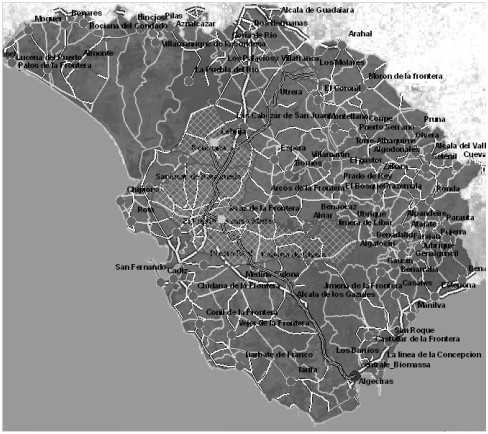
An area with a radius of 100 km with starting point in the Commune of Cadiz, was assumed as the cultivation basin of Cynara cardunculus and following the conveyance of the harvest to the coal electric power station of Endesa located in Los Barrios, Cadiz. Two biodiesel stations are present on such area (Biosur e BioOils), which were taken as reference in the event of transporting the fraction made up of oleaginous seeds to industries in order to extract the oil. Such area includes 89 Communes in which the cultivation of C. cardunculus is going to be introduced according to four possible scenarios relatively to the convertible land (see table below).
|
case I |
50% of fallow land |
|
case II |
50% of fallow land + 10% of current herbaceous crops |
|
case III |
50% of fallow land + 30% of current herbaceous crops |
|
case IV |
100% of fallow land + 30% of current herbaceous crops |
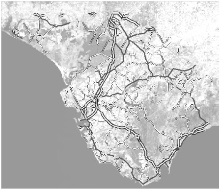 A road network was used in the region to support the process so that to take into account the impact of transportation based on the type of road and the means of transport that was considered (see figure 2). The application, based on ArcGIS v9.2 software, was developed with Visual Basic for Application. The following steps were performed to obtain the final result.
- Cartographic data acquisition and processing. At an early stage, the necessary cartography was acquired and processed to isolate the area around Cadiz. Then a road network database and an mdb with numerical input were prepared.
- mxd tool development. The second step involved the development of the tool to simulate the transportation logistics in the area around Cadiz.
The add-on modules allow the user to choose the product final use (biodiesel, electrical energy), to input the necessary data for the simulation, to update the system, to process the results and to manage the tool. A separate module allows to calculate independently the cost for each stocking centre. A “simulation” is a single analysis session: given all the required inputs, the outputs are the stocking centre ID, the total cost at the stocking centre, the total cost less the transportation cost to the power plant, the total collected product. To run a simulation one must specify:
- final use (biodiesel or electrical energy production);
- transportation mean;
- product type (biomass, seed, whole plant);
- analysed case (I–IV);
- involved Communes;
- stocking centre(s).
It was necessary to define the following factors. Communes: each of the n generic polygons forming the examined area. Every commune was assigned a value representing the product availability. Centroids: the stocking centres where the products are collected. The available production data were Commune based, so this is the smallest unit to consider (one Commune, one stocking centre). When more detailed data are available, it will be possible to better define the stocking centres. Road network: the road network concerning the area around Cadiz. It is formed by nodes and arcs, representing the actual roads between the main centres. Power plant: the power plant that will take delivery of the cynara products (for biodiesel or electrical energy production) The computation was carried out according the following formulas.
Costcs: total cost at a generic stocking centre (€/t)
Costcs = HarvCost·Ton + Σi (Ki-S·Dist(i-S))·Ton
Costtot_cs: total cost at the power plant of the product coming from the stocking centre S (€/t)
Costtot-cs = (Σi (HarvCosti·Toni + Σi (Ki-S·Dist(i–S))·Toni))/ΣiToni + + (KS-PP·Dist(S-PP))
- HarvCosti: generic harvesting cost per tonne (€/t);
- Toni: Commune “i” production (t);
- Ki-j: cost per kilometre and per tonne for the considered length i-j (€/(km·t));
- Dist(i-j): distance between network nodes i and j (km);
- KS-PP: cost per kilometre and per tonne for the considered length stocking centre – power plant (€/(km·t));
- Dist(S-PP): distance between stocking centre and power plant (km).
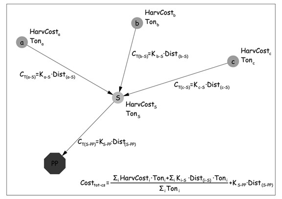 Chosen a stocking centre, the total cost at the power plant Costtot-cs (€/t) is the summation of the harvesting and transportation costs of each Commune (being zero the transportation cost of the biomass produced in the Commune used as stocking centre) and the transportation cost of the total collected biomass from the stocking centre to the power plant (see figure).
The basic function of a GIS system help resolve and find solutions to problems linked with geographic conditions. A GIS offers the chance to manage, analyse and process alphanumeric data in connection with spatial components, thus ensuring the consistency and integrity of the output data. An application that is available in the market was wanted for this job, with a specific tool to make estimations and to optimize the transportation logistic/ costs binomial related to the biomass harvest. This project fits in within the innovations in the field of a GIS, which are tools that are ever more refined and complete for treating and handling complex data, such that can grow into a technology integrated to information systems.
This job has enable the realization of a tool that is very helpful for analyzing biomass harvest according to the logistics, in terms of the most favourable individualization of stoking centres in connection with road networks that are present on the region and with the geographic position of the operating stations. The tool offers the following analysis modalities:
- analysis of the single stocking centre: the costs relative to the harvest biomass in a single chosen commune and transported to the station can be calculated;
- simulation on a set of stocking centres: chosen communes “n” and among these assumed m possible stocking centres, the costs relative to the harvest biomass can be calculated in the generic commune “i” and transported to the generic stocking centre “j” and the transportation costs of the entire biomass from the stocking centre “j” to the station.
The results are available graphically on 2 figure below.
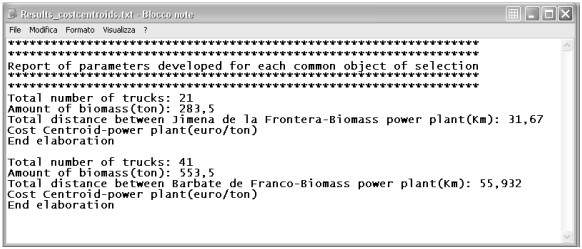
For each stocking centre are recorded:
- carriages number to move the chosen product according the mean of transportation;
- total amount of involved product;
- total distance;
- total cost at the stocking centre (harvesting and transportation)
The application SW_Cadiz is a simple but very important example of the potentiality offered by the GIS system. It enables the organization and storage of various type of information (territorial, productive, economical, etc), all into a combination of thematic layers linked with the respective geographical position, thus helping analysing and resolving problems linked with the management of the resources that are present on the territory. This is a first contribution to optimizing the transportation of biomass to transformation plants, reducing costs and the impact on the territory, environmentally speaking and in terms of traffic on road networks. Planning the conveyance of biomass to the station over the whole year, directly from production centres or through collection centres, helps reduce traffic, allows for a more rational use of transportation and provides a greater operative flexibility.